History
DURING THE FIRST HALF CENTURY of colonization following the English settlement at Jamestown in 1607, many colonists came from Europe who, with their descendants, played a remarkable part in the development and growth of America.
Settlements in the area that would embrace the Thirteen Original Colonies were then limited chiefly to the coastline. Colonists were found as far north as Pemaquid, one third the way up the Maine coast, and as far south as the area that become the Perquimans Precinct in northeastern North Carolina. Settlements south of Virginia, however, were at this early date embryonic.
The greatest period of early migration was the decade of the 1630s when so many English came to New England. The migration in a real sense began in 1630 with the arrival of the Winthrop Fleet to the Boston, Massachusetts area. The reasons for the migration and the reasons why many New Englanders returned after the end of the 1630s have been well studied. The great migration to Virginia occurred in the 1640s.
It has not been generally recognized that during the period of the earliest Virginia settlements other families were established in what is now the continental United States.
The three colonial powers which fostered settlements were disproportionately represented: England-91%, Holland-6%, All others-3%. It is apparent that most of the Swedes left after the Swedish Colony on the Delaware was conquered by the Dutch. The three per cent above may be divided into two almost equal groups: colonists from the British Isles exclusive of the English, and colonists from the Continent exclusive of the Dutch. The non-English colonists from the British Isles were almost entirely Scots.
The great majority were prisoners who were taken captive by the armies of Oliver Cromwell and brought to America in 1651 or 1652 Here they were sold as indentured servants for a period of seven years or less. Many of the "Scotch prisoners" were deported to Boston where they were acquired by planters from Maine to the Plymouth Colony.
After suffering the time as indentured servants, it is little wonder that the new American colonists were willing to face uncharted land and Indians to secure their freedom and their future.
Additional information on Charter of Virginia and settlement.

Early days in Kentucky bring to mind Indians, Daniel Boone, Benjamin Logan, Benjamin Pettit and those that followed.
The first settlers who came to Kentucky had to contend not only with the wild beasts of the forests, but with the equally savage Indian warriors. The first pioneers were men sent forth by the wisdom of God to found a new commonwealth.
The frontier was a land of running waters, groves, glades and primeval forests of stately trees so closely grown, a man could walk for days without stepping from under the shade.
The land was teeming with wild game. The hunting and trapping was good. The elk roamed at will and the gentle deer found seclusion. The shaggy-maned buffalo and mammoth predecessors had beaten down the earth in moving from salt lick to salt lick into traces over which the settlers came into this coveted country. Birds of bright plumage flitted from tree to tree. Flocks of wild geese and wild turkey abounded and the land was knee-deep in grass.
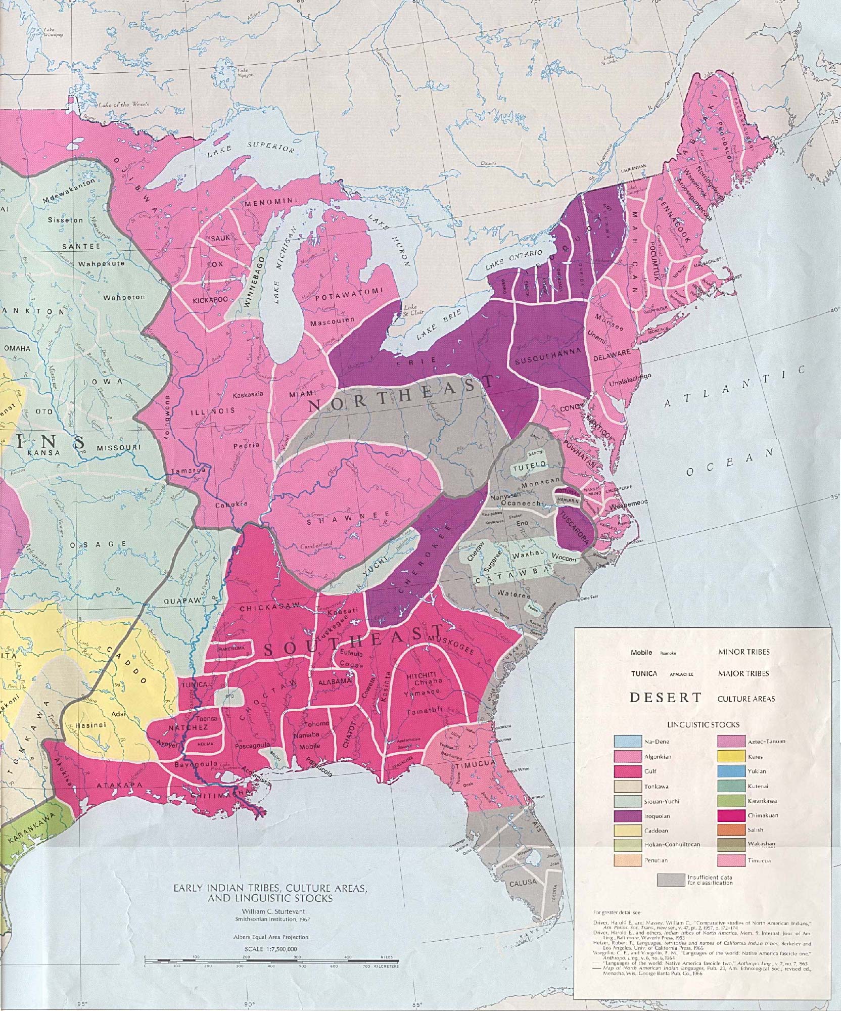
Map represents the locations and concentration of Indians in the areas
where colonists were settling.
Click on the map to see a larger image.
The news traveled fast to Virginia and North Carolina of the beautiful land of Kentucky, and its fertile land beyond the mountain. Daniel Boone, a footloose farmer from North Carolina, lead an expedition to find a practical way through the mountains into Kentucky in 1769. Boone found a natural passage, Cumberland Gap, in the heart of the mountains and showed it to others to follow.
Daniel Boone's first view of the "Beautiful Levels of Kentucky," was June 7th, 1769. Boone tarried in Kentucky until 1771. He spent most of this time in a cave on the waters of Shawnee, now in Mercer County.
The Colonists along the eastern shores, heard about the beauty of the country described by the wandering fur traders, who ventured inland to trade with the Indians. The Colonists and Pioneers became literally obsessed with a desire to secure homes in this "paradise," as Boone called it.
Soon, they found their way over the Alleghenies and through Cumberland Gap into the land which is now Kentucky. They came in an endless procession, bringing their wives, children, slaves, livestock and all their worldly goods. They came on foot and on pack horses, women riding and carrying their babies with the smaller children packed amidst the bedding in crates of hickory withes swung across the backs of gentle horses. The older boys drove the livestock ahead, while the men with rifles ready, kept vigilant eyes out for the Indians. the side of the trail. Just where they lie in oblivion.
France had claimed the country east of the Mississippi which included Kentucky. But after the French and Indian War 1763, Great Britain gained right to this region making Great Britain the leading colonial power in the world. British citizens had paid in blood and treasure to win their great empire. So by 1763 the struggle was finally settled. France had been defeated. Peace had come at last.
But peace brought new problems. During the long years of colonial warfare, the American seaboard colonies had been growing away from the mother country. The people who settled these colonies had learned to think of America as their land, as a place apart from England. They learned to love the new country that had brought most of them better lives than they or their fathers and mothers had known in the Old World. They began to think of themselves as Americans.
The walls of the Cumberland Gap echoed to the sounds of civilization's creaking wagon wheels and the crack of the driver's lash ... as settlers moved into the newly opened territory.
Many courageous and gallant young men came from Virginia to make their homes in Kentucky. Honor and wealth lay before them as well as exciting pleasures of a perilous undertaking. Bounty lands were granted to many of the officers and soldiers of the Virginia troops. Surveyors were sent to Kentucky by Virginia to mark off the land.
John Todd and his brother Levi Todd came as surveyors around 1773 and were followed the same year by a party of hunters and surveyors from Virginia. They were led by three brothers, James, George, and Robert McAfee, who later became prominent in the new country. After investigating the land, they settled on Salt River, in Mercer County. Soon thereafter the Shawnee Indians became so hostile to the new settlers, that it was dangerous for them to remain there. The Indians knew the value of their hunting ground, the endless forest where game was plentiful, and they were prepared to resist the early pioneers permanent settlements. The Shawnee and Cherokee claimed the land.
From the Shenandoah Valley, and the Blue Ridge Mountains, they came on foot, in wagons, and on horseback. Not all the wagons made it to Kentucky and not all the horses survived. In fact, the decision to follow the trail they called the Wilderness Road, through the Cumberland Gap into Kentucky was as dangerous a decision as any a frontiersman might make. Colonel William Whitley, an early Lincoln County resident whose magnificent home still stands as a tribute to pioneer Kentucky spirit, lamented that the Road Patrol he headed did little more than retrieve bodies of those who did not survive the trip.
Daniel Boone blazed the trail for the pioneers, hacking his way through the forests and undergrowth of the Cumberland Mountains, following buffalo trails -- traces, as they were then called -- that eventually led him to the place he founded his own settlement. Skagg's Trace, a trail named for two exploring brothers, branched from Boone's Trail at a place called Hazel Patch, and allowed Benjamin Logan and others to enter the area that would later see the rise of communities like Mt. Vernon, Crab Orchard, Danville, Hustonville, and Logan's own settlement -- Stanford. It wasn't known by that name then, of course, but then again, there were various names attached to Logan's settlement.
It was the year 1775 Benjamin Logan, his family and Benjamin Pettit with his wife, two young sons and slave, Molly, reached the convergence of three springs which were determined to be a fine location for a home. Logan was of Scotch-Irish heritage, born about 1741 in Augusta County, Virginia, one of the most predominately Scottish settlements in Colonial America. The recorded date of arrival at Buffalo Springs was May 1st, and a Welshman commented to Logan that the date corresponded to the canonization of St. Asaph, a monk who had lived in Wales. He suggested to Logan that the settlement be called St. Asaph's -- and although Logan agreed with the idea, the settlement was most often called Logan's Station, or Logan's Fort. The settlement later was renamed for a burrough in Lincolnshire, England that was originally known as Stanford, or "stony ford" in Old English, and became known as Stanford -- the county seat.
The Virginia Land Commission held its first court in Kentucky inside Logans Fort at St. Asaphs near Stanford, KY, October 13, 1779. This was the first opportunity the early settler had to claim the land he had struggled so hard to defend.If a settler had settled on property prior to that date and had made improvements on that land, he was entitled to Settlement Rights. He could travel to Logan's Fort and claim 400 acres of land at no charge. He could also buy a preemption of 1000 acres adjoining this land. This little fort was always busy with settlers coming to make their claims. The Oath of a Commissioner was issued to William Fleming, Edmond Lyne and James Barbour. They selected John Williams, Jr. the Clerk and the Court was attended by the Sheriff. They adjourned to the next day to hear proof and quiet the titles by issuing certificates to rightful claimants. Benj. Pettit is included as one of those present at the court to secure certificates for the land that they had claimed in Kentucky or as a representative for another person on October 20, 1779.
Lincoln County was established in 1780 as one of three original counties in the district of Kentucky, and comprised a third of the area before being divided numerous times to form smaller counties for the convenience of residents who were forced to travel long distances to the courthouse.
Lincoln County predates Abraham Lincoln -- and was actually named for General Benjamin Lincoln, who commanded the Southern Dept. of troops during the Revolution. Shortly after the county was named in his honor Lincoln accepted Cornwallis' sword as a token of the British surrender, a duty he performed at the request of George Washington.
Lincoln County is located in the Southern Knobs region of the state. The elevation in the county ranges from 760 to 1440 feet above sea level. Lincoln was one of the original counties in the Kentucky territory of Virginia. Parts of Lincoln County were used to form Boyle County in 1842, Casey County in 1806, Garrard County in 1796, Green County in 1792, Knox County in 1799, Logan County in 1792, Madison County in 1785, Mercer County in 1785, Pulaski County in 1798 and Rockcastle County in 1810.