|
|
Top of Page
|
|
|
|||||||||||||||||||||||||||||||||
|
|
|
|||||||||||||||||||||||||||||||||||
|
|
|
|||||||||||||||||||||||||||||||||||
|
|
|
|
||||||||||||||||||||||||||||||||||
|
|
|
|
|
|||||||||||||||||||||||||||||||||
|
|
|
|||||||||||||||||||||||||||||||||||
|
|
|
|||||||||||||||||||||||||||||||||||
Introduction
|
|
|||||||||||||||||||||||||||||||||||
|
|
Unlike most of the nine regions within this web-site the areas included within the “American Southwest” are primarily based upon the history of Spanish influence that grew north from Mexico into areas now a part of the United States. As such we believe that this region can be defined as encompassing the U.S. states of New Mexico and Arizona along with parts of west Texas, as well as southern Colorado, Utah, Texas, Nevada, and California.
Before American frontiersman could effectively reach the Pacific coast this “Spanish Barrier” would have to be overcome. The displacement of Spanish authority within this region began in earnest with the Texas War of Independence in 1835. It reached its peak during the 1840’s with the Mexican-American War. As a result the California Republic was created in 1846, and the U.S. Territories of Arizona and New Mexico were created. Spanish authority cessed to exist in the “American Southwest” region when 32,000 acres were sold to the U.S. in the Gadsden Purchase of 1853. The annexed territories, although comparable in size to Western Europe, were sparsely populated. The lands contained about 14,000 people in Alta California and fewer than 60,000 in Nuevo México, as well as large Native American nations such as the Navajo, Hopi, and dozens of others.
By the 1840’s many Americans began to look beyond the settlements of the states on the western bank of the Mississippi River, such as Missouri and the eastern part of Kansas. Here wagon trains formed at such places as Independence in Missouri to travel through the expansive prairies via several trails to the old Spanish colonial city of Santa Fe which up to this time was focused upon its lifeline to Mexico via the El Camino de Tierra Adentro. From Santa Fe westward bound migrants traveled to the Rocky Mountains and on to California on the Old Spanish Trail.
Westward migration into the Southwestern United States first opened with the great rush of migrants to the mountainous regions following the discovery of gold in California. Starting in the 1850’s prospectors used the Old Spanish Trail as they flooded into California, Nevada, Utah, and Colorado. The rush diminished significantly after the most workable deposits were exhausted and many mining communities disappeared. Yet the mining frontier helped lay the foundation for communities that would become important commercial centers for continued migrations into the Southwest. During the middle decades of the 19th century cattle ranching, brought more migration to the Southwest via the South Texas and Old San Antonio Trails. At first, cattle-ranchers settled in Texas to pursue range ranching, an activity requiring ranchers to drive huge herds of cattle hundreds of miles over open grasslands to designated slaughter depots. As railroads opened more eastern markets to beef, more sedentary forms of ranching took hold throughout the Southwest.
After the American Civil War an increasing number of migrants turned their attention to the old Spanish Southwest. Here they came into conflict with the Native-American Comanche, and Apache who like the Great Plains tribes allowed migrants to cross their territory but would not tolerate permanent settlements. When migrants moved into Colorado and New Mexico in violation of native sovereignty, the Indians waged a determined resistance. As a result the United States built and maintained many military posts in the region. The Army by the early 1890’s the Army had effectively subdued them and this region lay open to further settlement during the last final decades of the 19th century.
Soon after the ranchers came to the Southwest they were followed by the farmers. Thousands of migrants pushed into the Southwest after the passage of the 1862 Homestead Act awarded free grants of 160 acres to anyone who would improve the land. During the 1880s and 1890s, these migrants-turned-farmers clashed with ranchers over land usage and water rights. As with the Great Plains and other western areas a significant percentage of these migrants were newly arrived foreign immigrants, who preferred to take their chances with western farming rather than endure life in the rapidly industrializing eastern cities, or former slaves who sought refuge from the racially exclusive environment of the American South. Unfortunately these ethnic minorities seldom found increased opportunity or equality along the route west and settled along side of the previous Mexican population in the growing cities of the newly emerging Southwest. |
|
|
|||||||||||||||||||||||||||||||||
|
|
|
|||||||||||||||||||||||||||||||||||
|
|
|
|
|
|||||||||||||||||||||||||||||||||
|
|
List of routes
The following historic roads, trails and migration routes are defined as having their terminus in present day Arizona, New Mexico, West Texas, as well as southern Nevada, Utah, and Colorado. |
|
|
|
||||||||||||||||||||||||||||||||
|
|
|
|
||||||||||||||||||||||||||||||||||
|
|
|
Seaerching
for a Keyword
Use the “Find” function in the Edit pull down menu. You can also access this function by holding down the Control key while pressing the F key (Ctrl+F) on your keyboard. |
|
|
||||||||||||||||||||||||||||||||
|
|
|
Dealing with
a Broken Link
If you encounter a broken information link Cut & Paste the entry to your browser’s search component. |
|
|
||||||||||||||||||||||||||||||||
|
|
Keys to more
information and resources
Route: 5E1; Info. Link: (1); Map: (1); Image Gallery: (1); Road Trip: (1) Image Gallery = Link to a gallery of images that pertain to the route. Map = link to a map of this route. These maps have been developed from accounts found in various research sources. The route lines, on each map, have been linked to the current modern roads found to be the closest to the original route descriptions. Locations marked along the route are usually places named within the aforementioned research sources. Road Trip = link to a webpage about ad driving trip along this route. Here you will find an in-depth introduction to the route, links to additional information, as well as a map of the entire route and a listing of the U.S. counties through which it passes. The driving tour is divided into individual segments of 1 to 2 hours driving time. Each segment includes a map, directions, and features of historical interest. Info. Link = link to a webpage containing additional facts about this route. Route = each route has a specific Identifier code (ID Code). Each ID Code includes a number that identifies the cultural / geographical area of the United States in which we have developed information about the route, the letter of the alphabet under which it is filed and a dedicated number for the route. Thus data about the route designated as 5C2 would be found on the webpage for “Routes of the Southeastern Gulf Plains”, filed under the letter C route number 2*. *The specific route number will not conform to a descending order as new routes are added to the database. § = denotes an established or proposed road as listed in the Colorado Archives. |
|
|
|||||||||||||||||||||||||||||||||
|
|
Keys to the routes
|
|
|
|||||||||||||||||||||||||||||||||
|
|
|
|
|
|
|
|
|
|
|
|
|
|
|
|
|
|||||||||||||||||||||
|
|
|
|
|
|
|
|
|
|
|
|
|
|
|
|
|
|||||||||||||||||||||
|
|
|
|||||||||||||||||||||||||||||||||||
A
|
|
|
|
|
||||||||||||||||||||||||||||||||
|
Abeyta Pass Toll Road |
This 22 mile “toll road” was built c.1874 and appears to be an improvement of the former Cucharas & Sangre de Cristo Wagon Road that started at present day La Veta, CO. Today much of this road is US Route 160. § |
|
||||||||||||||||||||||||||||||||||
|
Abo Pass Trail |
This route departed the Santa Fe Trail about 12 miles southeast of Santa Fe and travelled in a southwesterly direction through the Abo Pass (Canyon). The trail reconnected with the Southern Trail around. |
|
||||||||||||||||||||||||||||||||||
|
Acoma-Zuni Trail |
|
See Zuni-Cibola Trail (7Z1). |
|
|||||||||||||||||||||||||||||||||
|
Alamosa and Pagosa Springs Wagon Road |
Established c.1878 this road ran, a distance of 85 miles, following Alamosa Creek westward upstream to Tipton’s Ranch at Cat Creek. Then to a branch near Lookout Mountain to Summitville. Then on to the summit of the divide between the Alamosa and East San Juan Rivers. From here the road travelled down the East San Juan River to Pagosa Springs. AKA Alamosa and Pagosa Springs Wagon Toll Road; Alamosa, Summit & Pagosa Springs Toll Road; and Alamosa San Juan & Pagosa Toll Road. § |
|
||||||||||||||||||||||||||||||||||
|
Ancient Way |
A network of Indian Trade Routes in New Mexico and Arizona, in use even before the arrival of the Spanish. One segment of this thoroughfare is known as the Zuni-Cibola Trail (7Z1).
|
|
||||||||||||||||||||||||||||||||||
|
Apache Pass Trail |
|
The trail left the Southern Trail at Soldiers Farewell Hill and commenced west to Apache Pass located in Arizona between the Dos Cabezas Mountains and Chiricahua Mountains, approximately 32 km (20 mi) E-SE of Willcox, Arizona. A station along the Butterfield Overland Mail route was built here around 1858. |
|
|||||||||||||||||||||||||||||||||
|
Apache Trail |
Originally a stagecoach trail that ran through the Superstition Mountains of Arizona. |
|
||||||||||||||||||||||||||||||||||
|
Arrowhead Trail |
The Arrowhead Trail or Arrowhead Highway was the first all-weather road connecting Los Angeles to Salt Lake City by way of Las Vegas. Built primarily during the auto trails period of the 1910s, prior to the establishment of the U.S. numbered highway system, the road was replaced in 1926 by U.S. Route 91 and subsequently Interstate 15. |
|
||||||||||||||||||||||||||||||||||
|
|
|
|||||||||||||||||||||||||||||||||||
B
|
|
|
|
|
||||||||||||||||||||||||||||||||
|
Beale Wagon Road |
This route left the Southern Trail near Los Lunas, NM and proceeded west along a route to Fort Mohave were the Mohave Road extended further west to Los Angeles. Earlier it was a part of U.S. Highway 66 and the Atlantic and Pacific Railroad. It now approximates current Interstate 40. |
|
||||||||||||||||||||||||||||||||||
|
Bradshaw Trail |
La Paz is known today as Ehrenberg. It was the first road connecting Riverside County to the Colorado River. aka The Gold Road |
|
||||||||||||||||||||||||||||||||||
|
|
|
|||||||||||||||||||||||||||||||||||
C
|
|
|
|
|
||||||||||||||||||||||||||||||||
|
Canon City, Grand River, and San Juan Road |
Established c.1862 this road ran westward from Canon City to the 28th mile of the Canon City-Hamilton road southerly via Poncha and Sawatch Passes to an intersection with Loring’s road from Ft. Garland to Salt Lake City along the Rio Grande del Norte. § |
|
||||||||||||||||||||||||||||||||||
|
Chávez Trail |
Established in 1864 this east-west trail crossed the southern part of central Arizona’s Verde Valley, linking Winslow, on the Colorado Plateau, with Prescott, in the Central Arizona Highlands, where Fort Whipple was also located. |
|
||||||||||||||||||||||||||||||||||
|
Chihuahua Trail |
A section of the El Camino Real de Tierra Adentro. Probably so named because it linked Chihuahua, Mexico with northern New Mexico. |
|
||||||||||||||||||||||||||||||||||
|
Cimarron Cutoff |
|
see Cimarron Routen(7C4) |
|
|||||||||||||||||||||||||||||||||
|
Cimarron Route |
This route was the portion of the Santa Fe Trail that cut through the Oklahoma Panhandle. It was shorter than the Mountain Route through Colorado by about 100 miles, AKA Cimarron Cutoff or Cimarron Trail. |
|
||||||||||||||||||||||||||||||||||
|
Cimarron Trail |
|
see Cimarron Route (7C4) |
|
|||||||||||||||||||||||||||||||||
|
Cooke’s Wagon Trail Route 7C5; Info. Link (1); |
This trail was established in 1846 when Philip St. George Cooke a U.s. Army unit known as the “Mormon Battalion”. The trail ran through present day Tucson and Yuma before crossing Southern California to San Diego. |
|
||||||||||||||||||||||||||||||||||
|
Crook Road |
|
see General Crook Road |
|
|||||||||||||||||||||||||||||||||
|
Cucharas - Elizabethtown Wagon Road |
|
See: Cucharas – Moreno Wagon Road (7C6) |
|
|||||||||||||||||||||||||||||||||
|
Cucharas & Moreno Valley Wagon Road |
Established c.1868, this 80 mile route ran from the south line of Huerfano County where it crosses the Cucharas River, extending up the valley, across Cucharas Pass and terminating in Moreno Valley. AKA Cucharas - Elizabethtown Wagon Road § |
|
||||||||||||||||||||||||||||||||||
|
Cucharas & Sangre de Cristo Wagon Road Route 7C7; Info. Link (1); |
near Blanca, CO
|
Established c.1868 this route began at the Francisco family homestead at present-day LaVeta, Co. the road extended westward up the South Veta (Abeyta) Creek crossing the Continental Divide at La Veta Pass and terminating at the headwaters of the of Sangre de Cristo Creek at 37.398 -105.524 in Costilla County, Colorado. Around 1874 this route also became a “toll road” known as the Abeyta Pass Wagon Road. § |
|
|||||||||||||||||||||||||||||||||
|
|
|
|||||||||||||||||||||||||||||||||||
D
|
|
|
|
|
||||||||||||||||||||||||||||||||
|
Denver and San Luis Valley Wagon Road |
Established c. 1865 this route started at Denver, then southerly to about three miles above the mouth of Plum Creek, thence southerly to where the road leading from Colorado City to South Park crosses the south branch of the South Platte River, thence southerly to where the roads leading from Canon City to California and to Montgomery diverge, thence southerly to the crossing of the Arkansas River, about fifteen miles above Canon City, thence southerly through Poncha Pass to the crossing of the Rio del Norte, thence by way of the Conejos agency and Los Pinos to the southern boundary of Colorado. § |
|
||||||||||||||||||||||||||||||||||
|
Dominguez-Escalante Trail |
(a circular route) |
This is the route taken, in 1776, by two Franciscan friars, Dominguez and Escalante, who were sent to search for an overland route from Santa Fe New Mexico to the recently established settlement at Monterey California. They made it as far as Southern Utah before being overtaken by winter and deciding to return to Santa Fe. |
|
|||||||||||||||||||||||||||||||||
|
Don Juan de Onate Trail |
The path taken, in 1598, by the explorer Don Juan de Onate who claimed what is now New Mexico for Spain. Starts roughly where Texas, Mexico & New Mexico meet and follows the east bank of the Rio Grande to the junction of the Rio Grande and the Rio Chama, north of Espanola. Later became part of El Camino Real de Tierra Adentro. |
|
||||||||||||||||||||||||||||||||||
|
|
|
|||||||||||||||||||||||||||||||||||
E
|
|
|
|
|
||||||||||||||||||||||||||||||||
|
Ehrenberg – Prescott Road |
Established in 1863 this road from the Colorado River was southernmost route of two main supply roads to the area of Prescott and Fort Whipple. Constructed from the river ports of La Paz and Ehrenberg. This toll road ran for about 150 miles over rough, unsettled Indian country. |
|
||||||||||||||||||||||||||||||||||
|
El Camino Del Diablo |
El Camino Del Diablo is a historic 250-mile Spanish colonial trail route, which originally ran from Caborca, Sonora through Quitovac, Sonoyta and Quitobaquito Springs, before continuing through extremely remote and arid desert to the Colorado River at Yuma Crossing, now Yuma, Arizona. From there, travelers could reach the Spanish colonies of California. |
|
||||||||||||||||||||||||||||||||||
|
El Camino Real de Tierra Adentro Route 7E3; Info. Link (1); Map (1); Images (1); Road Trip (1)
|
The “Royal Road to the Lands of the Interior” also sometimes called just Camino Real, this was the main trail from Mexico to Santa Fe, and followed the Rio Grande Valley. Also known as Chihuahua Trail, and El Camino Real. |
|
||||||||||||||||||||||||||||||||||
|
|
|
|||||||||||||||||||||||||||||||||||
F
|
|
|
|
|
||||||||||||||||||||||||||||||||
|
Fort Garland, Summit & Decatur Toll Road |
Established in 1875 from Fort Garland in Costilla County, westerly to the Rio Grande, crossing near the mouth of the Alamosa River, then extending westward up the Alamosa River valley to the Decatur Mining District in Conejos County, then to the Summit Mining District in Rio Grande County, about 75 miles. § |
|
||||||||||||||||||||||||||||||||||
|
Fort Smith-El Paso Trail |
This trail was blazed in 1849 by Capt. Randolph B. Marcy.
From El |
|
||||||||||||||||||||||||||||||||||
|
Fort Smith-Santa Fe Trail |
Name for the entire route to Santa Fe. The eastern segment generally known as the Santa Fe Road (6S7) ran from eastern Oklahoma, along the north side of the Arkansas River to near Great Bend, KS where it linked with the Santa Fe Trail. |
|
||||||||||||||||||||||||||||||||||
|
|
|
|||||||||||||||||||||||||||||||||||
G
|
|
|
|
|
||||||||||||||||||||||||||||||||
|
General Crook Road |
In 1871 General Crook located and marked this military supply road. Actual construction of a road started in the spring of 1872. By 1873, supplies began moving by pack train and in September 1874, the first wagon supply train left Fort Whipple for Fort Apache. The road was in continual use until the Rim Road was built in 1928. |
|
||||||||||||||||||||||||||||||||||
|
Gila Trail |
The part of the Southern Emigrant Trail that followed the Gila River downstream to its confluence with the Colorado River. see Southern Emigrant Trail |
|
||||||||||||||||||||||||||||||||||
|
Gold Road |
|
see Bradshaw Trail (7B2) |
|
|||||||||||||||||||||||||||||||||
|
Grayback Toll Road |
Near Sharpsdale, CO Near Russell, CO |
Established 1879, this road ran from the junction of the Mosca Pass Wagon Road (Huerfano Co., Rt. 580) and the mouth of Manzanares (Grayback) Creek upstream 4 miles to near the carbonate and iron mines then to the summit of the Grayback Mountain then down along Placer Creek to the Sangre de Cristo Wagon Road, (U.S. Rt. 160). § |
|
|||||||||||||||||||||||||||||||||
|
Gregg’s Route Route 7G4; Info. Link (1); |
Josiah Gregg was a Santa Fe trader who sought a southern alternative to the existing Santa Fe Trail. In 1840 he decided to follow the south side of the Canadian River and left Santa Fe with forty-seven men, twenty-eight wagons, two canons, 200 mules, and 300 sheep and goats. The expedition crossed the Texas Panhandle and passed near Trujillo Creek in what is now Oldham County, and then across the Llano Estacado. This venture marked Gregg's last return from New Mexico. |
|
||||||||||||||||||||||||||||||||||
|
|
|
|||||||||||||||||||||||||||||||||||
H
|
|
|
|
|
||||||||||||||||||||||||||||||||
|
Hardyville – Prescott Road Route: 7H1; Info. Link (1); |
Established in 1863 this road from the Colorado River was the northernmost route of two main supply roads to the area of Prescott and Fort Whipple. Constructed from the river ports of Fort Mohave and Hardyville, (now Bullhead City), this toll road ran for about 150 miles over rough, unsettled Indian country. Also known as the Hardyville Toll Road. |
|
||||||||||||||||||||||||||||||||||
|
Honeymoon Trail |
Southern segment of the Old Arizona Road. Mormon newlyweds from NM & AZ used this road to travel to the Temple to seal their marriages. |
|
||||||||||||||||||||||||||||||||||
|
Huerfano County Territorial Road |
Approximately |
Established c.1874, this road traveled between B.T. Howard’s Ranch in Huerfano County, traveled by way of St. Mary’s, then southwest through the ranch of Hamilton Brothers on the North Abeyta Creek, and thence to the mouth of the South Abeyta Creek. § |
|
|||||||||||||||||||||||||||||||||
|
|
|
|||||||||||||||||||||||||||||||||||
I
|
|
|
|
|
||||||||||||||||||||||||||||||||
|
|
|
|
|
|||||||||||||||||||||||||||||||||
|
|
|
|||||||||||||||||||||||||||||||||||
J
|
|
|
|
|
||||||||||||||||||||||||||||||||
|
Janos Trail |
A trade route established by the Spaniards, extending from the copper mines in New Mexico. Tradition has it that this trail used part of the Ancient Way. |
|
||||||||||||||||||||||||||||||||||
|
|
|
|||||||||||||||||||||||||||||||||||
K
|
|
|
|
|
||||||||||||||||||||||||||||||||
|
Kearny Trail |
|
see Southern Emigrant Trail |
|
|||||||||||||||||||||||||||||||||
|
|
|
|||||||||||||||||||||||||||||||||||
L
|
|
|
|
|
||||||||||||||||||||||||||||||||
|
La Bajada Hill Wagon Road |
The road was first built in 1598 by enlarging an old Indian trail, and was originally part of the Camino Real de Tierra Adentro (7E3). It ranks as the oldest European built highway in the United States. |
|
||||||||||||||||||||||||||||||||||
|
Laredo Road |
This road terminated at Villa de Delores probably near present day Zapata, on the Rio Grande River. Also the general term for the San Antonio-Laredo Road. |
|
||||||||||||||||||||||||||||||||||
|
LaJunta & New Mexico Road |
near Model, CO |
Established c.1876, this route ran from the Colorado-New Mexico border in the Canon of San Isidro (or Manco la Burra) Creek then down to San Francisco Creek, then down to the Purgatoire River then to Tempe Station on the Trinidad & La Junta Wagon Road that went on northeast to La Junta. § |
|
|||||||||||||||||||||||||||||||||
|
Las Animas City & Fort Union Wagon Rd. Route 7L4; Info. Link (1); |
|
Established c.1869, this wagon road travelled from the head of the south bank of Purgatoire Canyon in Las Animas County, CO, then southward along the Vega Redondo Creek upstream and across Sugarite Pass of the Raton Mountains in the direction of Fort Union to the Colorado-New Mexico Line. § |
|
|||||||||||||||||||||||||||||||||
|
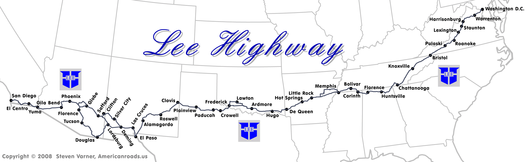
Lee Highway |
An early American transcontinental auto trail that connected Washington, D.C., and San Diego, California. An extension connected San Diego to Los Angeles and San Francisco via El Camino Real. The Lee Highway was a very important transcontinental route, and its name still appears on roads in Virginia, Tennessee, and Alabama to this day. |
|
||||||||||||||||||||||||||||||||||
|
Lower Road of Texas |
Established in 1849 by the U.S. Army for military and commercial purposes between San Antonio and El Paso. The route eventually ran west from the Gulf Coast and approximates today’s U.S. Route 90. Also known as the El Paso-San Antonio Road, or the South Texas Trail. |
|
||||||||||||||||||||||||||||||||||
|
|
|
|||||||||||||||||||||||||||||||||||
M
|
|
|
|
|
||||||||||||||||||||||||||||||||
|
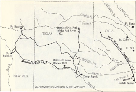
Mackenzie Trail |
Fort Griffin was the beginning of the Mackenzie Trail, which stretched across West Texas to Fort Sumner, New Mexico. |
|
||||||||||||||||||||||||||||||||||
|
Main Street of America |
|
see Mother Road |
|
|||||||||||||||||||||||||||||||||
|
Middle Creek Pass Toll Road Route 7M2; Info. Link (1); |
|
Established c.1874 this road ran from the mouth of Middle Creek Canon in Huerfano County, CO crossing the Sangre de Cristo Mountains at Middle Creek Pass, then to the Huerfano-Costilla County line, then westward 10 miles into Costilla County. § |
|
|||||||||||||||||||||||||||||||||
|
Midland Trail |
This historic route was a national auto trail spanning the United States. First road signed in 1913, it was one of the first, if not the first, marked transcontinental auto trails in America. AKA. Roosevelt Midland Trail |
|
||||||||||||||||||||||||||||||||||
|
Mojave Road |
Camp Cady, CA (site) |
The Mojave Road is the western extension of the Beale Wagon Road. It became a military wagon road in 1859 with the establishment of Ft. Mojave on the Colorado River. During the period of 1860-1880 the road served travelers heading west. Today it is a dirt road across what is now the Mojave National Preserve in the Mojave Desert in the United States. |
|
|||||||||||||||||||||||||||||||||
|
Mormon Trail (UT/CA) |
Beginning in 1849 Mormon pioneer Jefferson Hunt guided several parties of gold prospectors from Utah to California along the Old Spanish Trail. He used this trail when he was called by his church in 1851 to help create a Mormon settlement in San Bernardino, California. |
|
||||||||||||||||||||||||||||||||||
|
Mosca Pass Wagon Road |
As early as c.1874 this road travelled from the mouth of Mosca Creek in the San Luis Valley, up the creek and across the summit at Mosca Pass of the Sangre de Cristo Range, thence down the canyon on the east side, then into and thru Poison Canyon. After improvements over the next 20 years it extended down along the Hurefano River to Badito, CO totaling about 28 miles, from the point of beginning. The road at Mosca Pass charged a toll of $2 per wagon $1 for a horse and rider, a 50 cents for each head of cattle, sheep, etc. By 1892 about 30 to 40 wagons crossed the pass each day. AKA. Mosca Pass & Huerfano Toll Road; Mosca Pass & Poison Canon Toll Road; Mosca Pass Toll Road § |
|
||||||||||||||||||||||||||||||||||
|
Mother Road |
This highway became one of the most famous roads in America, covering a total of 2,448 miles. It served as a major path for those who migrated west, especially during the Dust Bowl of the 1930s. AKA. US Route 66, Will Rogers Highway; Main Street of America |
|
||||||||||||||||||||||||||||||||||
|
Mountain Monarch Wagon Road |
Established c.1879, this road ran from a point in the Wahatoya Valley in Huerfano County about 2 1/2 miles southeast of La Veta extending up the east side of the valley along the Wahatoya Creek then up to the head of the east canon of the West Spanish Peak or what is called Ducket Gulch a distance of about 5 miles from the beginning. § |
|
||||||||||||||||||||||||||||||||||
|
Mountain Route |
The portion of the Santa Fe Trail that followed mountain passes through Colorado. This was more rugged than the Cimarron Cutoff, but offered reliable sources of water. |
|
||||||||||||||||||||||||||||||||||
|
Music Pass Toll Road |
Established c.1880 this road ran from west side of Wet Mountain Valley where Cottonwood Creek comes out of the Sangre de Cristo Range into the Wet Mountain Valley, then up Cottonwood Creek and across the Sangre de Cristo Range thru Music Pass, then down Sand Creek to its mouth in the San Luis Valley in Saguache County. § |
|
||||||||||||||||||||||||||||||||||
|
|
|
|||||||||||||||||||||||||||||||||||
N
|
|
|
|
|
||||||||||||||||||||||||||||||||
|
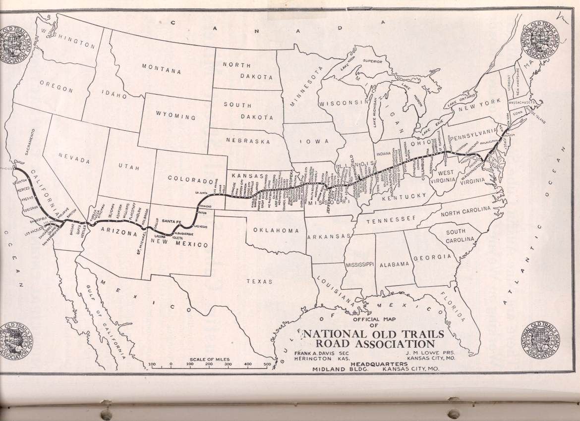
National Old Trails Road |
This route was established in 1912, and became part of the National Auto Trail system in the United States. It was 3,096 miles (4,983 km) long and stretched across the United States. Much of the route follows the old National Road and the Santa Fe Trail. AKA. Ocean-to-Ocean Highway |
|
||||||||||||||||||||||||||||||||||
|
|
|
|||||||||||||||||||||||||||||||||||
O
|
|
|
|
|
||||||||||||||||||||||||||||||||
|
Ocean-to-Ocean Highway |
|
see National Old Trails Road |
|
|||||||||||||||||||||||||||||||||
|
Old Spanish Automobile Trail |
An auto trail that once spanned the United States with a full 3,000 miles (4,800 km) of roadway from ocean to ocean. It crossed eight states and 67 counties along the southern border of the United States. Work on the auto highway began in 1915. By the 1920s, the trail was complete from Florida to California. |
|
||||||||||||||||||||||||||||||||||
|
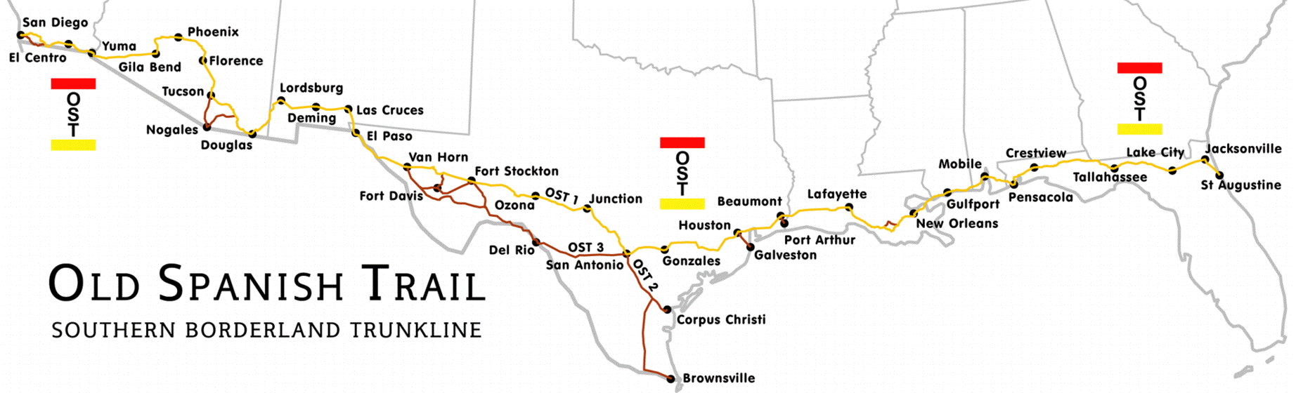
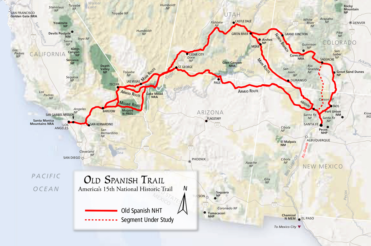
Old Spanish Trail Route 7O2; Info. Link (1),(2); Map (1); Images (1),(2),(3); Road Trip (1); |
The Old Spanish Trail is a historical trade route which connected the northern New Mexico settlements with southern California. Approximately 1,200 mi (1,900 km) long, it is considered one of the most arduous of all trade routes ever established in the United States. Explored, in part, by Spanish explorers as early as the late 1500s, the Trail saw extensive use by pack trains from about 1830 until the mid-1850s as it was generally too rough to safely accommodate freight wagons. |
|
||||||||||||||||||||||||||||||||||
|
Old Trader’s Trail Route 7O3; |
|
Located in northern New Mexico, this was most likely a local term for a portion of the Old Spanish Trail that ran from Santa Fe to California. |
|
|||||||||||||||||||||||||||||||||
|
Ozark Auto Trails |
A network of locally maintained roads and highways organized by the Ozark Trails Association that predated the United States federal highway system. The roads ran over a series of routes and were maintained by both private citizens and local communities. |
|
||||||||||||||||||||||||||||||||||
|
|
|
|||||||||||||||||||||||||||||||||||
P
|
|
|
|
|
||||||||||||||||||||||||||||||||
|
Parkview & Fort Garland Freight Road |
Established c.1877 this road ran from Parkview in Rio Arriba County, New Mexico, extending up the left branch of the Chama River and over the most practical crossing of the San Juan Mountains, then to Fort Garland, Colorado. § |
|
||||||||||||||||||||||||||||||||||
|
Pass Creek Toll Road |
approximately |
Established c.1880 this road ran, in Huerfano County, CO southward up Pass Creek and across the summit of the Sangre de Cristo Range at Pass Creek Pass, then down Sangre de Cristo Creek in Costilla County to the intersection of the Abeyta Pass Toll Road and the Denver & Rio Grande Railroad above the upper water tank on the south bank of Sangre de Cristo Creek. § |
|
|||||||||||||||||||||||||||||||||
|
Pueblo & San Juan Wagon Road |
Established c.1874 this road proceeded from Pueblo up the Arkansas Valley to the foot of the Greenhorn Range, then across the range via Hardscrabble Creek to the Rosita mines and on into the Wet Mountain Valley, then over the Sangre de Cristo Range, at Music Pass then west to Del Norte in Saguache County to connect with the road to San Juan County. The distance from the beginning is about 125 miles. § |
|
||||||||||||||||||||||||||||||||||
|
|
|
|||||||||||||||||||||||||||||||||||
Q
|
|
|
|
|
||||||||||||||||||||||||||||||||
|
|
|
|
|
|||||||||||||||||||||||||||||||||
|
|
|
|||||||||||||||||||||||||||||||||||
R
|
|
|
|
|
||||||||||||||||||||||||||||||||
|
Raton Wagon Road Route 7R1; Info. Link (1); |
Established c.1870 this road was an improvement upon the original Trindad, Raton Wagon Road from Trinidad to the Raton Mountains. This route travelled up Raton Creek to the summit of the mountains and the boundary line between Colorado and New Mexico. It eventually crossed through Raton Pass to the town of Raton, NM. See Trindad, Raton Wagon Road. § |
|
||||||||||||||||||||||||||||||||||
|
Roosevelt Midland Trail |
|
see Midland Trail |
|
|||||||||||||||||||||||||||||||||
|
Route 66 |
|
see Mother Road |
|
|||||||||||||||||||||||||||||||||
|
|
|
|||||||||||||||||||||||||||||||||||
S
|
|
|
|
|
||||||||||||||||||||||||||||||||
|
Saguache & Medano Pass Wagon Road |
Established c.1872 this road started in Colorado Springs and ran easterly to the north line of Bear Baca Grant No. 4 near its northwest corner, then east along north line to the base of the mountains then southeasterly along the base to the mouth of Medano Creek, then up Medano Creek to the top of the pass, then southerly to the Huerfano River to intersect the Mosca Pass Wagon Road near the foot of Mosca Pass. § |
|
||||||||||||||||||||||||||||||||||
|
San Antonio - El Paso Road |
|
See Lower Road of Texas (7L6). |
|
|||||||||||||||||||||||||||||||||
|
Sangre de Cristo Wagon Road Route 7S2; Info. Link (1); |
Established c. 1864 this route travelled from Fort Garland in Costilla County up along the Sangre de Cristo Creek to Sangre de Cristo Pass (aka. LaVeta Pass), then over the Sierra Madre Range, AKA Sangre de Cristo Toll Road. § |
|
||||||||||||||||||||||||||||||||||
|
Santa Fe Trail Route 7S3; Info. Link (1); Map (1); Images (1); Road Trip (1) |
The Santa Fe Trail was a 19th-century transportation route through central North America. Pioneered in 1821 by William Becknell, it served as a vital commercial and military highway until the introduction of the railroad to Santa Fe in 1880. Near Lakin, Kansas travelers could choose from the Mountain Route (7M9) or the Cimarron Route (7C4). |
|
||||||||||||||||||||||||||||||||||
|
Silver Cliff & San Luis Valley Toll Road Route 7S4; Info. Link (1); |
Established c. 1881, this road ran from Silver Cliff via Lake of the Clouds at head of Swift Creek across the Sangre de Cristo Range to the headwaters of Rito Alto Creek down the creek to the San Luis Valley. § |
|
||||||||||||||||||||||||||||||||||
|
Skeleton Canyon Road Route 7S5; Info. Link (1) |
An ancient trail used by the Apaches in their migrations in the San Simeon Valley between Skeleton Canyon, and Mexico's Sierra Madre Mountains. This route was once a main route for smugglers between the United States and Mexico. It is probable that the route is approximated by modern Arizona State Route 80, north of Douglas. |
|
||||||||||||||||||||||||||||||||||
|
South Texas Trail |
|
See Lower Road of Texas (7L6). |
|
|||||||||||||||||||||||||||||||||
|
Southern Emigrant Trail Route 7S6; Info. Link (1); Images (1); |
An often used term for the early southern overland route to California, but actually a network of trails this route for immigration into from the eastern United States that followed the Santa Fe Trail to New Mexico during the California Gold Rush. From Santa Fe it ran south to Mesilla, New Mexico where it tied in with Lower Road of Texas (7L6). From here it again turned west across Arizona to Yuma on the Colorado River. This part of the network of trails included the Gila Trail (7G2), Kearny Trail, and Butterfield Stage Trail. From Yuma it crossed southern California to Los Angeles. |
|
||||||||||||||||||||||||||||||||||
|
Southern California Emigrant Trail |
Another name for that portion of the Southern Emigrant Trail (7S6) that ran through Southern California from the Colorado River to Los Angeles. Emigrants followed this trail from the river to Warner’s Ranch where there was a branch route to San Diego. Also known locally as the Old Emigrant Trail, and the Canyon Road to the Colorado. |
|
||||||||||||||||||||||||||||||||||
|
Southern Trail |
Another name for that portion of the Southern Emigrant Trail (7S6) that ran from the end of the Santa Fe, Trail to the Colorado River in Arizona. It came was heavily used during California Gold Rush when 49ers followed Cooke’s Wagon Trail (7C5) south. At Santa Cruz, Mexico they travelled north to Tucson and west to Yuma, Arizona. |
|
||||||||||||||||||||||||||||||||||
|
Summit Creek & Wagon Creek Toll Road Route 7S9; Info. Link (1); |
|
Established c.1876 this road to run from the head of Summit Creek to Wagon Creek, then westward to Sangre de Cristo Creek at Russel, then down Sangre de Cristo Creek to the Sangre de Cristo Toll Road, then following down the said toll road turning to the right up Spring Branch Gulch, to Fort Garland, about 15 miles. §
|
|
|||||||||||||||||||||||||||||||||
|
|
|
|||||||||||||||||||||||||||||||||||
T
|
|
|
|
|
||||||||||||||||||||||||||||||||
|
Taos Mountain Trail Route 7T1; Info. Link (1); |
|
An historic pathway for trade and business exchanges between agrarian Taos (New Mexico) and the Great Plains (Colorado) from pre-history (1100 A.D.) through the Spanish Colonial period and into the time of the European and American presence. |
|
|||||||||||||||||||||||||||||||||
|
Temple Trail |
This 80 mile trail was used, between1871-77, to haul materials to build a Mormon Temple at St. George. |
|
||||||||||||||||||||||||||||||||||
|
Trinidad & Costilla Road Route 7T3; Info. Link (1); |
Established c.1875, this road would meet the need to cross the Culebra Range to the Sangre de Cristo Grant. A possible route would have started from Trinidad west along the Purgatoire River then down the South Fork at Weston to intersection with the Cucharas & Moreno Valley Road near Torres the over San Francisco Pass, then up Gold Creek to the headwaters of Costilla Creek to Costilla. § |
|
||||||||||||||||||||||||||||||||||
|
Trinidad & Moreno Valley Wagon Road Route 7T4; Info. Link (1); |
Established c.1868 this road to run from Trinidad to Rifenburg’s Mill at the mouth of Long’s Creek, extending southwestward upstream in Long’s Canyon, crossing the divide at the head of Red River, then to Virginia City, (now Tincup, CO), and the southern boundary of Colorado. §
|
|
||||||||||||||||||||||||||||||||||
|
Trinidad, New Mexico & San Juan Road Route 7T5; Info. Link (1); |
Established c.1876 to run from Trinidad up the middle fork of Purgatoire River to the southwesterly Cucharas Elizabethtown, New Mexico, Wagon Road, then following said road southwest to the south boundary of Colorado, then via the headwaters of the Vermejo River to Costilla Pass, then west to Costilla River, then downstream to the Rio Grande near the town of Costilla, New Mexico, then south to Taos, New Mexico. § |
|
||||||||||||||||||||||||||||||||||
|
Trinidad- Raton Wagon Road Route 7T6; Info. Link (1); |
Established c.1865 this route went from Trinidad on the Purgatoire River in Las Animas County, then to the south boundary of Colorado over the Raton Mountains by way of the old route known as the Santa Fe or Bents Old Fort Road. Also known as the Raton Wagon Road. § |
|
||||||||||||||||||||||||||||||||||
|
|
|
|||||||||||||||||||||||||||||||||||
U
|
|
|
|
|
||||||||||||||||||||||||||||||||
|
Upper Road (Texas) |
This route was established by the U.S. Army in 1849. It ran between the Gulf coast of Texas and El Paso. The route travelled through present-day Houston, and Austin. It crossed the Pecos River at Horsehead Crossing. |
|
||||||||||||||||||||||||||||||||||
|
|
|
|||||||||||||||||||||||||||||||||||
V
|
|
|
|
|
||||||||||||||||||||||||||||||||
|
|
|
|
|
|||||||||||||||||||||||||||||||||
|
|
|
|||||||||||||||||||||||||||||||||||
W
|
|
|
|
|
||||||||||||||||||||||||||||||||
|
Will Rogers Highway |
|
see Mother Road |
|
|||||||||||||||||||||||||||||||||
|
|
|
|||||||||||||||||||||||||||||||||||
X
|
|
|
|
|
||||||||||||||||||||||||||||||||
|
|
|
|
|
|||||||||||||||||||||||||||||||||
|
|
|
|||||||||||||||||||||||||||||||||||
Y
|
|
|
|
|
||||||||||||||||||||||||||||||||
|
|
|
|
|
|||||||||||||||||||||||||||||||||
|
|
|
|||||||||||||||||||||||||||||||||||
z
|
|
|
|
|
||||||||||||||||||||||||||||||||
|
Zuni-Acoma Trail |
Part of the Ancient Way, linking the Acoma Pueblo located approximately sixty miles west of Albuquerque in Cibola County, New Mexico, and Zuni Pueblo in McKinley County, New Mexico. Also known as the Acoma-Zuni Trail. |
|
||||||||||||||||||||||||||||||||||
|
Zuni Trail |
Established in 1831 by the Edwin Young company who followed an ancient Native-American trail from the pueblo of Zuni to the Pima villages on the Gila River. They then followed the river west to the Colorado and crossed into California at Yuma. The portion of this trail from Pima to Yuma is also known as the Gila Trail (7G2). |
|
||||||||||||||||||||||||||||||||||
|
|
|
|||||||||||||||||||||||||||||||||||
|
|
Image Gallery
During our research we have collected images and photographs that are of general interest to a variety of historic American roads, trails and migration routes. Some of them are presented on this website because we believe they tend to provide the reader with additional information which may aid in the understanding of this topic as well as our ancestors past lives. |
|
|
|
||||||||||||||||||||||||||||||||
|
|
Use this LINK to see our “Image |
|
Gallery” that pertain to this topic. |
|
|
|||||||||||||||||||||||||||||||
|
Images of Historic Trails and Roads in the Southwestern United States |
|
|||||||||||||||||||||||||||||||||||
|
|
· Images for Historic Trails and Roads in Arizona · Historic Trails and Roads in Southern California |
· Images for Historic Trails and Roads in New Mexico |
|
|
||||||||||||||||||||||||||||||||
|
|
|
|
|
|||||||||||||||||||||||||||||||||
|
|
|
|
|
|
|
|||||||||||||||||||||||||||||||
|
|
Use the power of Google™ to find more interesting images about this topic. This button will link you to the Google Images Search page. Enter the topic |
|
you are searching in the box and click “Search Images”. At the “Images” display page you will see the image, as well as the website of which it is associated. |
|
|
|||||||||||||||||||||||||||||||
|
|
|
|||||||||||||||||||||||||||||||||||
|
|
|
Inyernet resources
|
|
|
|
|||||||||||||||||||||||||||||||
|
|
The Google search engine button and following web sites may provide |
|
You with additional information to assist your research about this topic. |
|
|
|||||||||||||||||||||||||||||||
|
|
|
|
|
|||||||||||||||||||||||||||||||||
|
· A Listing of Historic Roads in America · Historical U.S. roads and trails - Wikipedia · U.S. Historical Maps - Perry-Castañeda Collection · Early American Roads and Trails · US Migration Trails and Roads – Family Search Wiki · American Migration Trails: Eastern United States · Historic trails & roads in the U.S.A. by state - Wikipedia |
· American Migration Fact Sheets · Map guide to American migration routes,1735-1815 · Links to Migration Routes Websites · Westward Expansion: Trails West · Migration Message Boards – Ancestry.com · The African-American Migration Experience · United States Migration (Internal) – Family Search Wiki · Map of U.S. Trails – Geocities.com · Migration Routes, Roads & Trails · Ancient Traces and Roads - Waymarking.com |
|
||||||||||||||||||||||||||||||||||
|
|
|
|
|
|||||||||||||||||||||||||||||||||
|
· Arizona Emigration & Immigration - Family Search Wiki · Colorado Emigration & Migration - Family Search Wiki · Nevada Emigration & Migration - Family Search Wiki · New Mexico Emigration & Immigration - Family Search Wiki · Texas Emigration & Migration - Family Search Wiki · Utah Emigration & Migration - Family Search Wiki · Historic trails and roads in Arizona - Wikipedia · Historic trails and roads in Colorado - Wikipedia · Historic trails and roads in Nevada - Wikipedia · Historic trails and roads in New Mexico - Wikipedia |
· Historic trails and roads in Texas - Wikipedia · Historic trails and roads in Utah - Wikipedia · Southern Trails to California · Nevada Historic Highways And Trails Maps · Commerce Of The Prairies By Josiah Gregg · Utah State History: Markers & Monuments · Historic Trails of the Old West |
|
||||||||||||||||||||||||||||||||||
|
|
|
|
|
|
|
|||||||||||||||||||||||||||||||
|
|
The following Link will take you to our library of genealogy reference books. Here you will find books about historic American roads, trails, and paths. In addition, there are texts that pertain to ethnic and religion groups, history, geography as well as other books that will assist you with your research. |
|
|
|||||||||||||||||||||||||||||||||
|
|
This Link will take you to our |
|
collections of reference books. |
|
|
|||||||||||||||||||||||||||||||
|
|
|
|||||||||||||||||||||||||||||||||||
|
|
About This Webpage
|
|
|
|||||||||||||||||||||||||||||||||
|
|
CONTACT INFORMATION
We do like to hear from others who are researching the same people and surnames. We
need your help to keep growing! So please Email photos, stories, and other appropriate information about this topic.
RULES OF USE We only ask that if you have a personal website please create a link to our Home Page. -- This webpage was last updated on 01 April 2014 ©copyright 2013-14 |
|
|
|||||||||||||||||||||||||||||||||
|
|
|
|
|
|
|
|||||||||||||||||||||||||||||||


.png)
.png)
.png)
.png)
.png)
.png)
.png)
.png)
.png)
.png)